
Table of content
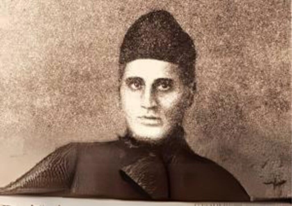
In the archives of history, some names shine brightly, etched in books and monuments, while others remain hidden in the shadows—waiting to be discovered, celebrated, and remembered. One such name is Radhanath Sikdar, an unsung Indian genius whose remarkable contribution to science and mathematics was to accurately measure the height of Mount Everest in the 19th century.
This is the fascinating story of the man who calculated the world’s highest peak, a story that left an indelible mark on the history of cartography, geodesy, and exploration.
Early Life of a Genius
Born in October 1813 in the intellectually vibrant city of Kolkata, Radhanath Sikdar was gifted with an extraordinary aptitude for mathematics. His talent was evident from a young age and was soon nurtured by educators at the prestigious Hindu College (now Presidency University), one of the leading institutions in colonial India.
At Hindu College, he was mentored by Henry Louis Vivian Derozio, a forward-thinking educator and reformist who inspired students to think critically, question authority, and challenge outdated traditions. Derozio’s influence shaped Sikdar’s analytical mind, encouraging him to explore the deeper truths behind numbers, geometry, and logic—skills that would later prove crucial in solving one of the greatest geographical challenges of his time.
Joining the Great Trigonometrical Survey of India
In 1831, at just 18 years old, Sikdar joined the Great Trigonometrical Survey of India, a monumental British-led effort to map the vast Indian subcontinent with scientific accuracy. The project, originally conceived and led by Sir George Everest, was one of the most ambitious cartographic efforts of the 19th century.
This wasn’t just about drawing maps—it involved hauling massive theodolites, braving wild terrain, dealing with extreme climates, and performing highly technical trigonometric calculations. Amidst the highly hierarchical and racially biased structure of British colonial institutions, Sikdar stood out. His mathematical brilliance and relentless dedication quickly made him one of the Survey’s most valuable assets. For those interested in epic journeys and surveying challenges, Arunachal Trips offers an incredible way to explore India’s rugged terrain while learning about its history.

The Historic Measurement of Mount Everest
The turning point in Sikdar’s career—and in global geography—came in 1852. Under the leadership of Andrew Scott Waugh, the new Surveyor General of India, the team was tasked with analyzing data collected from the Himalayan range.
At the time, the mountain known only as “Peak XV” had not been formally studied. Using sophisticated trigonometric calculations and adjusting for both the curvature of the Earth and atmospheric refraction, Sikdar determined that Peak XV was, in fact, the tallest mountain in the world.
His calculations yielded a height of 29,002 feet above sea level. Today, with the help of modern satellite measurements, we know Everest to stand at 29,029 feet (8,848.86 meters). Sikdar’s estimate, made without GPS or aerial tools, remains a staggering achievement—accurate within a mere 27 feet.
This achievement echoes in modern geography and exploration, similar to the precision seen in the Rann of Kutch Festival, where travelers experience the vast beauty of Gujarat’s landscapes while diving into its rich history.
Despite this monumental contribution, the mountain was not named after Sikdar. Instead, it was christened Mount Everest, in honor of Sir George Everest, who ironically had retired before the peak’s height was even calculated and had never seen it himself.
Why Wasn’t the Peak Named After Sikdar?
Although George Everest himself reportedly opposed naming the peak after him—arguing that local names like Chomolungma (Tibetan) or Sagarmatha (Nepali) should be used—the colonial administration went ahead with it. Sikdar’s role was largely left out of official British accounts, reflecting a broader pattern of colonial erasure of Indian contributions to science and intellectual history.
But time has a way of correcting oversights, and today, Radhanath Sikdar is increasingly recognized as the true mind behind Everest’s first measured height.
The Legacy of Radhanath Sikdar
Sikdar’s story is a testament to the power of intellect, perseverance, and the pursuit of truth. His work laid foundational principles for modern geodesy, surveying, and cartography—fields that are essential to everything from GPS technology to climate research.
Yet, for decades, his contributions remained buried under the weight of colonial narratives that privileged Western figures over local talent. It’s only in recent years that Indian scientists, historians, and educators have begun to reclaim Sikdar’s rightful place in history.
Honoring a Forgotten Hero
At DarkGreen Adventures, we believe that travel is not just about exploring nature—it’s about understanding the people and stories behind the places. Whether you’re trekking through the Himalayas or hiking across the Western Ghats, the land holds secrets, legends, and histories that can inspire us deeply.
Sikdar’s journey—from a mathematics prodigy in colonial India to the man who measured the tallest mountain on Earth—is more than a tale of numbers. It is a symbol of resilience, intellect, and unrecognized brilliance.
As you stand at the foot of mighty peaks or climb mountain trails with us, remember: these summits were first measured not by machines, but by human minds like Radhanath Sikdar’s. His story serves as a beacon of inspiration, reminding us that even in the face of adversity, genius and determination can scale the highest heights.
Connecting the Legacy to Our Journeys
At DarkGreen Adventures, our treks are more than physical journeys—they are educational, cultural, and spiritual expeditions. We strive to uncover and share stories like that of Sikdar’s because they deepen our appreciation for the places we explore.
When you travel with us, you become part of a larger narrative—one that honors the land, respects its history, and celebrates the people who’ve shaped it. Join us on upcoming treks across India and Nepal, where we don’t just show you the trails—we share the stories behind them.
Whether you’re discovering Mauritius Holiday Packages or trekking through Arunachal Pradesh, every journey connects you to the stories that have shaped these places.
Frequently Asked Question
Q1. Who was Radhanath Sikdar?
Ans. Radhanath Sikdar was a 19th-century Indian mathematician and surveyor who first calculated the height of Mount Everest in 1852 while working for the Great Trigonometrical Survey of India.
Q2. How did Sikdar measure Everest’s height without modern tools?
Ans. He used trigonometric principles, theodolite data, and meticulous calculations that accounted for atmospheric refraction and Earth’s curvature.
Q3. What height did Sikdar calculate for Everest?
Ans. Sikdar’s figure was 29,002 feet (8,839.8 meters), remarkably close to the current official height of 29,029 feet.
Q4. Why was Mount Everest not named after Sikdar?
Ans. Despite his achievement, colonial policies led to the mountain being named after Sir George Everest. Sikdar’s role was overshadowed due to systemic racial bias.
Q5. What is the significance of the Great Trigonometrical Survey?
Ans. It was a massive cartographic project that mapped India with unprecedented precision and laid the groundwork for modern geodesy.
Q6. Is Radhanath Sikdar recognized today?
Ans. While he remained obscure for years, growing awareness has led to renewed appreciation of his contributions in academic and scientific circles.
Q7. What is geodesy, and how is Sikdar related to it?
Ans. Geodesy is the science of measuring Earth’s shape, orientation, and gravity field. Sikdar’s Everest calculations were a landmark in this field.
Q8. How does DarkGreen Adventures integrate history into treks?
Ans. We focus on meaningful travel. Our guides often share historical insights, legends, and lesser-known stories about the places we explore—like that of Radhanath Sikdar.
Very well written. Keep up the good work.
Great article 👏🏻👏🏻👏🏻